
Ngamring Fm
Type Locality and Naming
South Lhasa Block - Xigaze forearc Basin. The Ngamring Formation was erected by Wu Haoruo, Wang Dongan and Wang Liancheng in 1977. The section for the designation is in Yajue of the Ngamring County. The reference section is from Jialie to Kawei through Dala of the Xigaze County, Xizang.
Li Pu (1955) called a set of flysch deposits in the Xigaze area as “Xigaze System”. The Geological Team of South Xizang (1963) renamed it as the Xigaze Gr, and divided it as the Qiuwu Fm, Dazhuka Fm and Xigaze Fm.
Synonym: Angren Fm. The nomination of the “Angren Formation” appears in some publications.
Lithology and Thickness
The Ngamring Formation is comprised by thick flysch deposits dominated by conglomerates, volcaniclastic sediments, shales and siltstones with minor hemipelagic, carbonate-rich intercalations. Cross-bedding within turbidites indicates southward transport.
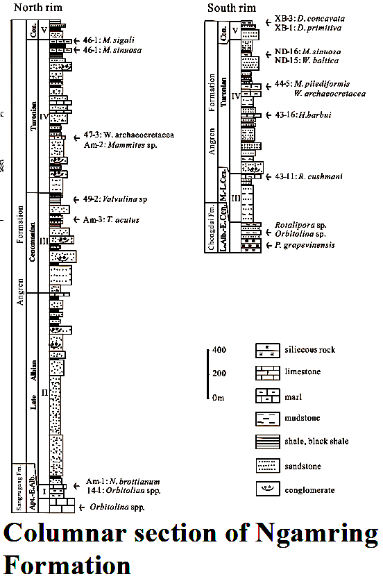
The Ngamring Formation is represented by sandy, sandy-clayey, clayey and calcareous flysch sediments, which is divided into five members. First member is built up by sandy and clayey flysch consisting of rhythms of gray medium-bedded greywacke, gray black sandy shale and shale. Second member clayey flysch consisting of rhythms of yellow gray shale, thin-bedded fine sandstone and siltstone. Third member clayey and calcareous flysch consisting of rhythms of yellow gray and gray fine sandstone, shale, siltstone and slaty clayey and crystal limestone. Fourth member sandy flysch consisting of moderately thick and thick-bedded greywacke with moderately thin-bedded sandstone and shale, mainly sandstone. Fifth member sandy and clayey flysch alternated with sandy flysch, forming rhythms of fine sandstone and shale, sandstone and shale, siltstone, fine sandstone and shale. The formation is more than 2700 m thick.
It comprises of thick flysch deposits dominated by conglomerates, volcaniclastic sediments, shales and siltstones with minor hemipelagic, carbonate-rich intercalations. The pebbles are predominantly andesites, with minor tonalites and granodiorites. Limestone pebbles are common. Cross-bedding within turbidites indicates southward transport.
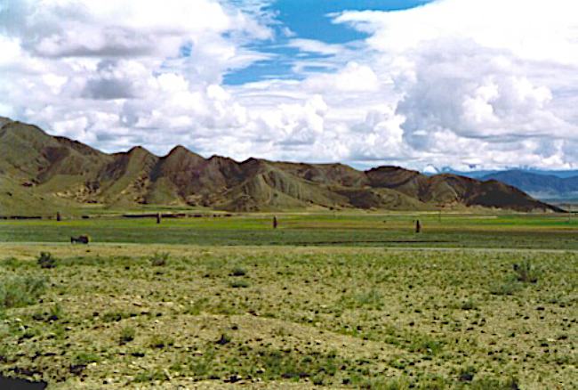
[Figure: Outcrop of Ngamring Formation near Xigaze City, southern Tibet]
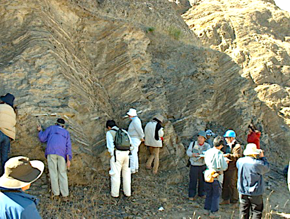
[Figure: Ngamring Formation in Xiaburi section, 6 km southwest of Xigaze City, southern Tibet]
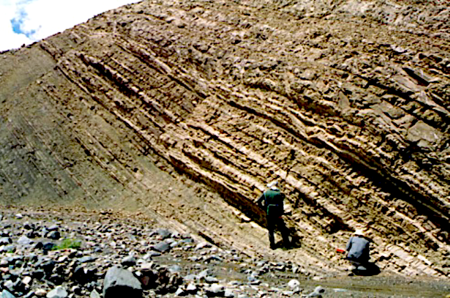
[Figure: Outcrop of Ngamring Formation at Kade of Xigaze, southern Tibet]
[Figure: Type section of Ngamring Formation 20 km west to Xigaze City]
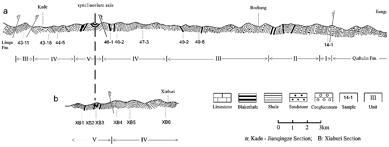
a: Kade-Jiangqingze section; b: Xiaburi section
[Figure: Columnar section of Ngamring Formation]
Relationships and Distribution
Lower contact
In the Sangsang area of Ngamring County, it contacts by fault with the underlying strata at the Sangzugang Village.
Upper contact
In the Sangsang area of Ngamring County, it lies conformably under the Padana Fm.
Regional extent
The Ngamring Formation occurs in the Xigaze and Ngamring areas. The present formation is illustrated as tectonic interpretation of the area as partially eroded large synclinorium. Both the southern and northern rims of the formation contain broadly synchronous sedimentary deposits, even though they are represented by different lithofacies (Fig.). The southern rim rests on the Chongdui Fm and the northern rim on the Shangzugang Fm or Qiabulin Fm.
GeoJSON
Fossils
In the Xigaze and Ngamring areas it yields foraminifera, gastropods and bivalves, etc. The microfossils, mainly foraminifera were found mostly in light colored hemipelagic marls and shales intercalated within the Ngamring Formation. The foraminifera data suggest the biostratigraphic zonation for the Ngamring Formation: late Albian Orbitolina assemblage; middle- late Cenomanian R. cushmani-H. barbui assemblage; Turonian Mammites assemblage; middle Turonian M. pilediformis-W. archaeocretacea assemblage; late Turonian M. sinuosa-M. sigali assemblage; early Coniacian D. primitiva assemblage; and late Coniacian D. concavata assemblage. Therefore, the biostratigraphy of the Ngamring Formation indicates a late Albian to late Coniacian age (Wan et al., 1998) .
Age
Depositional setting
Lithofacies characteristics and sediment composition are suggestive of an upper - middle continental slope depositional environment (flysch). In the Xigaze region, the Ngamring Formation represents the major sedimentary fill of the forearc basin. Cross-bedding within turbidites indicates southward transport.
Additional Information